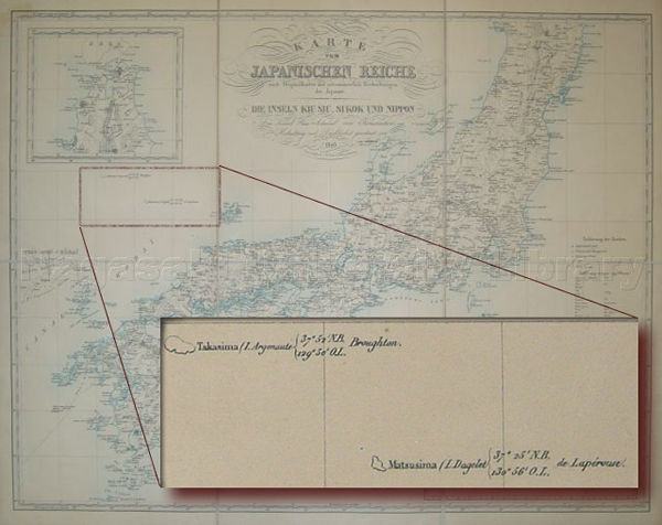
Map by Siebold in 1840
In 1787, the French discovered Ulleungdo and named the island “Dagelet.” The British discovered Ulleungdo two years later, in 1787, and named it “Algonaut.” However, the French and British mapped the island at different locations, which caused people to assume that there were two islands. In fact, a Dutchman named Siebold, who had lived in Japan for several years, made a map of Japan that labeled the island the British mapped as Takeshima and the island the French mapped as Matsushima. The following is Siebold’s 1840 map:
| north latitude | east longitude | |
| Algonaut island (ENG) | 129degrees 50minutes | 37degrees 52minutes |
| Dagelet island (FRN) | 130degrees 56minutes | 37degrees 25minutes |
| Actual Ulleungdo | 130degrees 53minutes | 37degrees 29minutes |

Map by Siebold in 1840
Siebold’s mislabelling of Takeshima and Matsushima caused confusion even for Japanese mapmakers since it labeled a non-existent island as Takeshima. Koreans have used this mistake by Japanese mapmakers to claim that Japanese maps show Takeshima/Dokdo to be Korean territory. Koreans make their claim based simply on the names, ignoring the shapes of the islands and their location.
In 1849, a French ship named “Liancourt” finally discovered Takeshima/Dokdo and named the islets “Liancourt Rocks,” which still did not clear up the confusion since the non-existent island was still being mapped. The following is an 1867 Japanese map that shows the non-exisitent island labeled as Takeshima (竹嶋), Ulleungdo labeled as Matsushima (松島), and Liancourt Rocks (Dokdo/Takeshima).
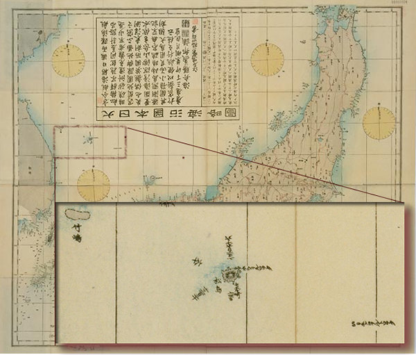
Map by Kaisyu Katsu in 1867
(Algonaut is "Tekeshima", Dagelet is "matsushima",
and Takeshima/Dokdo is "Liancourt Rocks")
By superimposing the Google Earth map on some of Japan’s old maps, you can see that the Takeshima on them was not referring to present-day Takeshima/Dokdo, but to the non-existent island mapped by the British.
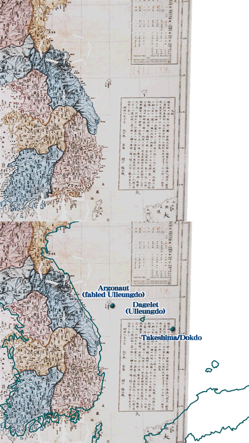
Sekiguchi in 1875
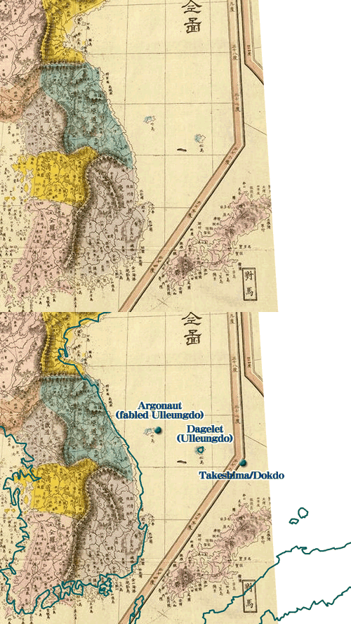
Kinseki Mori in 1877
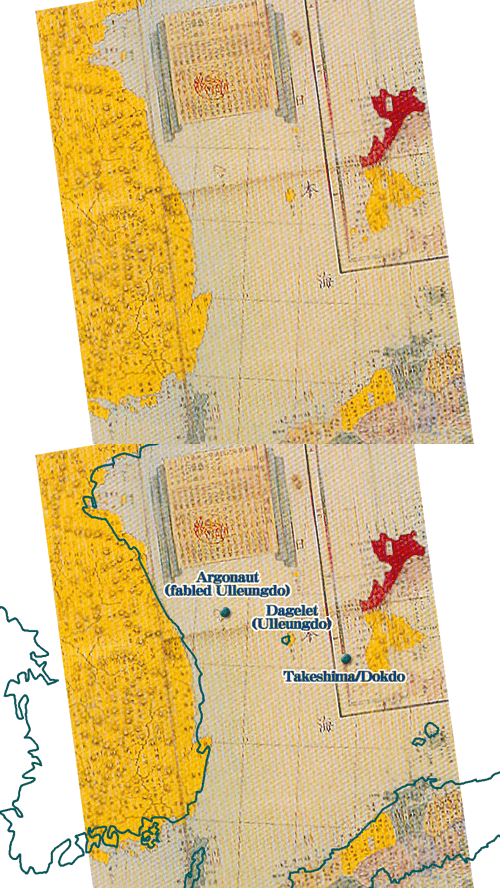
Kiyosuke Yamamura in 1878
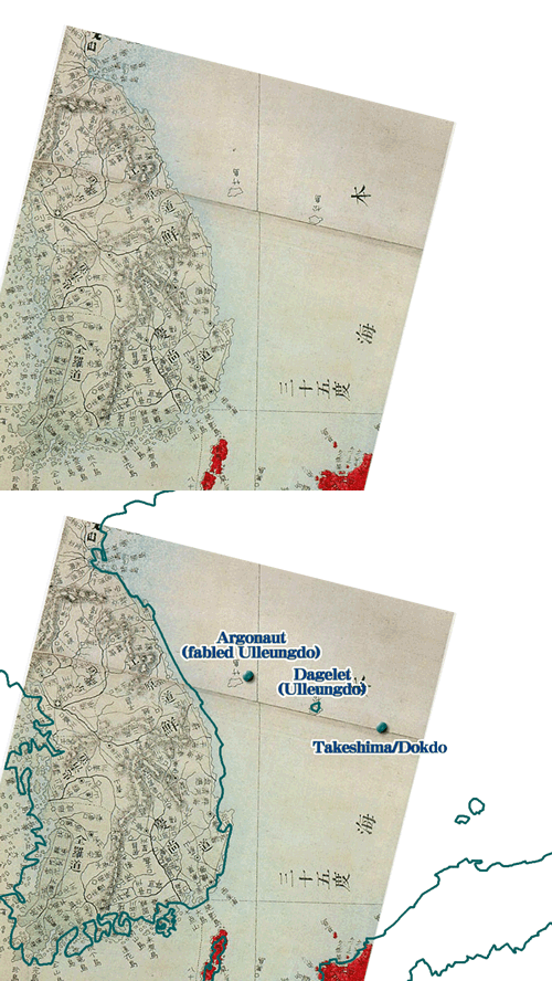
Bunzo Kimura in 1882
This site concludes that Matsushima was Takeshima/Dokdo based only on the European
and Japanese mapping errors and an inaccurate Japanese record made by Watanabe.
However, Watanabe’s island name recognition has been denied by Tanabe,
who points out the possibility that Matsushima was referring to Usando,
which was a neighboring island of Ulleungdo, as the Korean maps above have
shown. Even the Japanese Ministry of Foreign Affairs has denied Watanabe’s
claim.
The map confusion continued until 1883. Japan sent a ship to survey the
area in1878 and 1880. The Japan Navy survey ship determined that Matsushima
was being used to refer to Ulleungdo. The ship also discovered that there
was an island next to Ulleungdo named Takeshima.
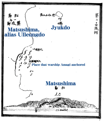
Warship Amagi in 1880
Based on the survey results, Japan decided to give Ulleungdo the name “Matsushima”. However this information is limited in Japan Navy and Ministry of Foreign Affairs. Ministry of Interior that did not know this information, and makes a map which made Takeshima Algonaut in 1881.
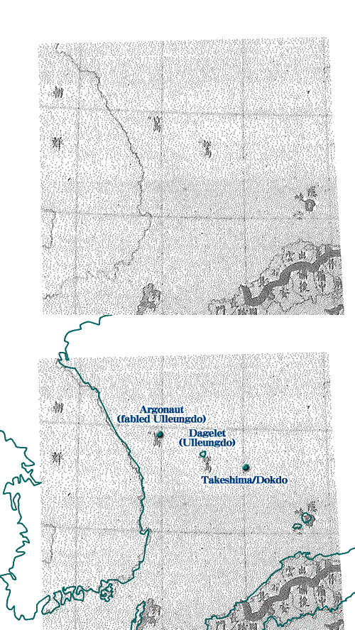
Ministry of Interior in 1881
When Japan made Liancourt Rocks a part of Japanese territory in 1905, the
name was changed to “Takeshima.”
| Year | Record | Author | Argonaut | Ulleungdo | Jyukdo | Takeshima (Dokdo) |
| Before 19C |
Takeshima | Igashima | Matsushima | |||
| 1840 | Map | Siebold | Takashima | Matsushima | ||
| 1867 | Map (大日本沿海略図) |
Katsu Kaisyu (officer:samurai) |
Takeshima | Matsushima HoriruRokku*2 |
RiankuruRokku*1 | |
| 1869 | Archives (Notification of visit to Takeshima:竹島再見届) |
Fuji Morichika (officer:samurai) |
Takeshima Matsushima |
Matsushima (Rumor) |
||
| 1870 | Map (大日本四神全図) |
Hashimoto Gyokuran (Civilian) |
Takeshima | Matsushima HouriruRokku*2 |
RienkorutoRokku*1 | |
| 1870 | Archives (Bill about Matsuhima:松島之議) |
Watanabe Kouki (Director of the Ministry of Foreign Affairs) |
It doesn't exist. | Takeshima Matsushima |
Matsuhima Hornet island*2 |
|
| 1870? | Archives (Kill Watanabe's bill) |
TanabeTaichi (Director of the Ministry of Foreign Affairs) |
Matsushima (He pointed out the possibility of "Matsushima" is two or more islands.) |
|||
| 1870 | Archives (Investigation report in Korean country) |
Sada Hakubou (officer of the Ministry of Foreign Affairs) |
Takeshima | (Matsushima) | (Matsushima) | |
| 1876 | Archives (Bill for register of title deeds) |
Shimane prefecture | Takeshima | Manoshima | Matsushima | |
| 1877 | Map | Mori kinseki (Civilian) |
Takeshima | Matsushima | ||
| 1877 | Map | Kashihara Yoshinaga (unknown) |
Matsushima | Riancourutorokku*1 | ||
| 1878 | Archives (Investigation of warship:軍艦天城調査(竹島版図所属考)) |
Japan Navy | Matsushima (old name Takeshima) |
(Takeshima:Korean name) | ||
| 1880 | Archives (2nd Investigation of warship:軍艦天城調査(竹島版図所属考)) |
Japan Navy | Matsushima | (Takeshima:Korean name) | ||
| 1881 | Archives (Consideration about the dominium of Takeshima:竹島版図所属考) |
Ministry of Foreign Affairs | Takeshima, alias Matsushima |
|||
| 1881 | Map (大日本府県分割図) |
Ministry of Interior | Takeshima | Matsushima | ||
| 1882 | Archives (Ulleungdo search diary:鬱陵島検察日記) |
Lee Gyu-won (officer of Korea) |
Matsuhima (hearing from japanese fisharman) |
|||
| 1883 | Archives (Making a passage for Ulleungdo is prohibited.鬱陵島渡海禁止) |
Japan government | Takeshima, alias Matsushima (Name of Japan) |
|||
| 1889 | Book Korean water way (朝鮮水路誌) |
Department of the navy | alias Matsushima | Chikusyo (Jyukdo) |
RiancourutoRokku*1 | |
*1: Japanese pronunciation of Liancourt Rock. Liancourt Rock is a name
of Takeshima/Dokdo named by France.
*2: Japanese pronunciation of Hornet rocks. Liancourt Rock is a name of
Takeshima/Dokdo named by Britain. .
Japan has never recognized Korea’s claim on Takeshima/Dokdo, and there are no Korean maps or documents that show Korea even knew about the islets before Japan incorporated them in 1905. The Korean claim that Usando was a reference to Takeshima/Dokdo has been proven false by Korea’s own maps and records.
The evidence is clear. Takeshima (Dokdo) is historically and legally Japanese territory, which means Korea is now illegally occupying the islets.